ALMOST A MONTH IN THE DESERT 2011
March 26, 2011
 |
| Adam Haydock overlooking the Gobblin Valley Desert beyond the State Park |
 |
| Watchman Campground Trail Zion National Park |
When I got to Zion I set up at the Watchmen campground hiking up the short but moderate and impressive trail which was a nice introduction to Zion’s beauty. I wanted to make sure I got a good night sleep since I would be tackling the the famous Left Fork Subway system the following morning. I woke up at 6AM to get to the trailhead of wildcat canyon and discovered 6 inches of snow and a river of water flowing down the trail to Russell Gulch which would be my entry point into the subway.
 |
| Wildcat Canyon trailhead from the top Zion National Park |
I prepared my ropes, put on my wetsuit, and set my pack for a waterproof hike. As I was making it down Russell Gulch I had to rappel a few times before I got to the left fork.
 |
| The Subway Zion National Park |
The waterfalls from the melting snow were no joke and at 44 degrees even a 3mm wetsuit has its limitations but making it into the left fork I found I could ride the current downstream a bit (feet out in front of you with flotation in your backpack to recline on) till I made it to the subway system.
 |
| The Subway Zion National Park |
The views were amazing and worth every huff and puff. Coming out of the subway and to continue my hike to the trailhead I left my wetsuit on to retain heat but after miles of climbing over rock and logs it became a mental game till I got to the steep climb up to the trail head.
 |
| Waterfalls in the Left Fork Zion National Park |
Staging my ascent I made it to the trailhead and looked back to see what a wonderful hike that was. I highly recommend preparing for this hike with waterproof bags wetsuits ropes anchors and water boots. It is a strenuous hike.
 |
| Weeping Rock Zion National Park |
The next day I hiked up to Observation point which was around 2100 ft from the trailhead but again the views did not disappoint me at all. Simply amazing!!!
 |
| Observation Point Zion National Park |
I continued onto the east mesa and back down to echo canyon onto hidden canyon which has small waterfalls a cool canyon breeze and wonderful formations.
 |
| Trail to Observation Point Zion National Park |
Next day I went to the southwest desert which has a petrified forest within the desert lands. It was beautiful to see the mountain range and ponder the terrain 250 million years ago when these petrified trees were alive.
 |
| Southwest Desert Zion National Park |
The desert was quiet as can be fossils next to mineral deposits and golden eagles and hawks few above.
 |
| Southwestern Desert Zion National Park |
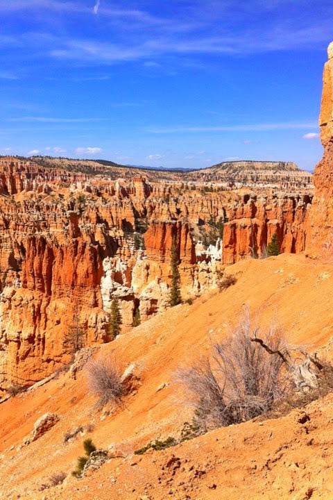
After being in the southwest desert for a couple days I ventured to Bryce Canyon National Park which had 4 ft of snow at the top and very muddy slippery trails.
 |
| Bryce Canyon |
I strapped my crampons and went to the peak of promitory point to take a few breathtaking snapshots of the canyons below. I realized that the events that made these hoodoos were happening as I was standing there so I limited my time before I became apart of the park.
 |
| Bryce Canyon |
I went over to hike the peek a boo hike before dark and after sliding gripping and washing down the trail to peek a boo loop I was amazed to see these wonderful formations towering above me. I highly recommend Bryce Canyon to Anyone venturing through Utah.
 |
| Bryce Canyon |
After indulging in Bryce Canyons wonder, I went to the Desolate lands of the Escalante.
 |
| Dry Frk Escalante |
Now I knew that hole in the rock road was long, graded, and dirt but I did not grasp the fact that my Honda accord has to get me back home to Chicago so I had to Skip the coyote gulch and Egypt hikes and just went to the Dry Fork for Spooky, Brimstone, and Peek A Boo slot canyons.
 |
| Spooky Slot |
These Canyons rock!! Going through spooky was dark and so narrow you have to turn to the side to get through the system.
 |
| Spooky Slot |
You also have to chimney up some small restrictions to continue to where it opens and closes back up again. Peek a boo had some small arches in the beginning and opens up in the middle of the hike.
 |
| Brimstone Slot |
You can connect peek a boo with spooky as well. Brimstone was a bit farther down the gulch but the walls of the canyon were also amazing to see with day light creeping into the canyon floor and stone formations embedded into the sandstone rock.
 |
| Entrance to Brimstone Slot |
There are no marked trails so You have to set waypoints and or break out the map and compass and nav your way around the dry fork and for that matter the Escalante is remote with a 50+ mile dirt road so I recommend food water extra gas and a 4 wheel drive car.
 |
| Peek-A-Boo Slot |
You can make it on a two wheel car like my Honda endured through but if you get stuck in the rain everything turns into mud and clay. I can’t prove this at this point but I have heard that the tow is up to 1000.00. I would say the Escalante is the most remote part of this trip. After making it out of hole in the rock I went to Calf Creek for a night and a nice hike to Calf Creek Falls.
 |
| Lower Calf Creek |
It was an easy hike through the desert canyons and valley to the falls with crystal clear water and rainbow trout in the river. The waterfall was spectacular as the moss grew on the sides and the cold run off from the snow caps poured over the ledge I was tempted to jump in headed back to the car for the drive to Capital Reef.
 |
| Capital Reef |
Capitol Reef National Park is another amazing park in Utah which seems to be overlooked by a lot of people. It has some of the canyons and cliffs like Zion but more colors of yellow mixed into the red sandstone.
 |
| Natural Arch Capital Reef |
I stopped to see grand wash and ventured into Capital Gorge where spectacular cliffs water tanks arches natural bridges and pure minerals were just laying around everywhere. I passed the Pioneer Register to see the names of the old pioneers that have carved their names into the slick rock as well as what appears to be a name that was shot into the slick rock.
 |
| Trail Register Capital Reef |
I couldn’t get out to cathedral valley so due to my car again and the rain so I hiked up to Navajo knobs and the rim overlook. The views were amazing at the top with the cliffs of capital reef stretching for miles.
 |
| Observation point Capital Reef |
I got a mid day start and went off track to the leprechaun slot canyon system which proved to be a nice side hike from the trip.
 |
| leprechaun slot canyon |
The dark tall narrow canyons gave an eerie feel to the canyon like something was actually living in them which added to the excitement of rappelling down the right fork into the slot.
 |
| leprechaun slot canyon |
No water was encountered but a nice cool breeze inside with tall sheer cliffs and slick rock canyons.
 |
| leprechaun slot canyon |
If you have time and are in the lake Powell area I highly recommend this system but bring map compass gps with you so you can find your way in and out of the system.
 |
| leprechaun slot canyon |
After the Slot Canyons, I went to Goblin valley state park which has a very interesting valley of “goblins” that have been eroded over a 100 million year span. The “goblins” are worth checking out and to spend a night at the state park since they got showers and a bathroom.
 |
| Gobblin Valley State Park |
My journey continued to the Canyon lands island in the sky district which is nothing short of an amazing experience.
 |
| Mesa Arch |
I hiked down into the valley via alcove springs and hiked around the crater via the syncline trail which has a very spiritual feel once you get into the valley.
 |
| Gobblin Valley State Park |
I set up camp on the rim of Murphy’s point which was one of the best views I have ever had and I can’t wait to get back there and spend more time there.
 |
| False Kiva Island In the Sky |
All the rim views are amazing but watch out of thunderstorms since one was brewing in the night I had to move my site inland more to avoid lightening.
 |
| Green River island In The Sky |
My Last visit was to Arches National Park.
 |
| Delicate Arch |
I knew there were a lot of people there which there were but the park itself does not disappoint.
 |
| Canyonlands |
Hiking through the primitive trail to see the arches and hiking up to delicate arch I was able to get a feel for how these arches were made with the wind tunnels and the sand blowing creating these fascinating formations.
 |
| Crater loop Hike island In The Sky Canyonlands |
After 104 hiked miles, 9256 ft of hiked elevation, and one pair of boots, I feel like I have only scraped the surface of the beauty that Utah has to offer.
 |
| Echo Canyon Zion National Park |
From deep snow, slot canyons, mountain climbing, cold water wading/swimming, bouldering, chimneying, rappelling, strenuous slope hiking, dust storms, and sleepless nights to the wonders of the petrified forest, the jaw dropping views of the cliffs and canyons, the fascinating colors of the desert and the spiritually almost Zen like feeling that comes with being immersed in this natural wonder makes me happy to know that this is a great piece of Americana and something that everyone should experience if it is just for a few days at designated campsites on paved trails or backcountry hikes leaving no trace.

0 comments