APOSTLE ISLANDS NATIONAL LAKESHORE KAYAK TO DEVILS ISLAND
July 09, 2014
 |
Devil's Island Apostle Islands National Lakeshore
|
Changing things up a bit and going north instead of south was a great decision as the nights were cool and the region contained 22 kayak accessible islands to choose from in a peaceful place to relax. On the north tip of Wisconsin in Lake Superior, The Apostle Islands National Lakeshore is a region of islands dating back to before dinosaurs existed when volcano's aggressively developed the land. My first visit to the Apostle Islands was a memorable one but this time around, the return to the Apostle Islands was with the right equipment, company, and the best route which turned out to be 56 miles of kayaking in pristine weather conditions barely missing a hail producing thunderstorm and 4-6ft waves.
The sandstone of the Apostle Islands were deposited during the late Precambrian era, about one billion years ago, and form the basement rock for all the islands. The upper and lower layers are in the Precambrian Bayfield Group and were deposited by streams. The Devils Island Formation, between the sandstones, shows how sand-flats that were covered by shallow ponded water. Terraces, wave-cut benches, and elevated beaches show evidence of higher levels of Lake Superior. High bluffs and glacial drift erode to provide sand for today's sandspits and cuspate forelands. The Apostles were glaciated repeatedly, with the most recent glaciation was by the Vanders Ice Lobe approximately 12,000 years ago. Following these extreme periods of rising lake levels controlled by land rebound, the Apostles were separated from the peninsula to form the archipelago. Above the bedrock there are regionally rare habitats that exist in the lakeshore. These habitats include old growth forests.
Three years ago I went to visit the Apostle Islands National Lakeshore for a 5 day trip to visit some waterfalls and sea caves around this regional part of Wisconsin. I went Shipwreck Diving one of the days and got to see the FinMcCool and the Lucere. The FinMcool is just south of Bayfield in a debris field of other small shipwrecks and artifacts from the turn of the last century's shipping industry. I was able to swim through the Fin McCool's structure which had gears and other material laying around the location. She Sank in 1959. We also dove the Lucerne which foundered in 1886 due to bad weather off of Long Island taking her Iron Ore and her full crew with her down to a depth of 20ft. I was able to swim out to see the Fedora which ran aground at Red Cliff in 1901. She has the skeletal remains of the hull, kealson and side panelling with fasteners and wood debris laying around. This one was interesting to check out as it is right near the Red Cliff campground and you can swim out to it. Some pieces of the wreck protrude out of the water.
Check out pics of the wrecks here: https://www.flickr.com/photos/exploration-worldwide/sets/72157633273034234/
The Ottawa and the Coffinberry which sank in 1917 are two wrecks I went to visit with the kayak which also have remains similar to the Fedora with some structure out of the water. These two are close to shore and the Coffinberry is right on the shoreline. I was also able to take My Advanced Elements Inflatable kayak out to Basswood Island from the Ref Cliff campground to see Honeymoon rock which was about a 5 miles round trip.
I also had the chance to Kayak and hike the Squaw bay cliffs and kayak the sea caverns which was a very impressive display of sandstone erosion on the mainland shoreline. One section had a fissure crack of sorts that you can kayak into which was beautiful both from the top down and from the bottom up. I also went to Madeline island to swim the cliffs and sea caverns while fighting the biting flies which were rather aggressive that day! I finally made an attempt to get to the sand island sea caves which turned out to be a disaster in itself. I do not recommend traveling out on an inflatable kayak no matter how good it is!!
Check out pics of the wrecks here: https://www.flickr.com/photos/exploration-worldwide/sets/72157633273034234/
 |
| Shipwreck of the Fedora |
 |
| Honeymoon rock Apostle Islands |
I also had the chance to Kayak and hike the Squaw bay cliffs and kayak the sea caverns which was a very impressive display of sandstone erosion on the mainland shoreline. One section had a fissure crack of sorts that you can kayak into which was beautiful both from the top down and from the bottom up. I also went to Madeline island to swim the cliffs and sea caverns while fighting the biting flies which were rather aggressive that day! I finally made an attempt to get to the sand island sea caves which turned out to be a disaster in itself. I do not recommend traveling out on an inflatable kayak no matter how good it is!!
This trip we drove up north through the night and got to the visitor center around 4 am so we could pick up our permits for camping on the islands when the facility opened at 8am. After a few hours of light sleep, we obtained our permits and headed out to cornucopia which was across the peninsula to take our kayak rescue course and rent the tandem kayak from lost creek adventures. We got to the facility and were greeted by a helpful staff that helped us prepare for the rescue course in the morning so we can be dropped off at sand bay in the afternon. After going over the course and performing the kayak rescue techniques, we set out to sand bay to load our kayak and set out on our route on lake Superior's apostle islands.
We loaded the kayak and set out by heading northeast toward Raspberry Island than to make the crossing to Oak Island which is where the first campsite was located. The wind was with us as we paddled over 1 and 2 ft. waves aiming right for the lighthouse on Raspberry Island. It was an adjustment that we had to go through to prepare ourselves with being on the water for 5 days but working as a team, we were able to make it to the first stop on the beach of Raspberry Island |
| Raspberry Island Apostle Islands National Lake shore |
 |
| Raspberry Island Apostle Islands National Lake shore |
After another hour on Lake Superior we got to Oak Island where we tied off the kayak, set up camp and went on a hike on one of the trails on oak island. There are a series of hikes to do and it is pretty a pretty big island next to Stockton Island so we did just a small portion. We started on this trail and we noticed a lot of pine trees, ferns, and.....flying bugs!! It was almost like we were each assigned to 5 bugs as they orbited around our heads taking their chances at penetrating through our clothes in an attempt to draw blood or to bite us for some ridiculous reason. We wore bug nets and sprayed a high concentrate of Deet which appeared to help a bit but it didn't stop the mosquito's from breaking through my gloves and risking death for a sip of blood but most of the daring mosquito's didn't survive my agitated wrath.
 |
| Trail to the overlook point on Oak Island Apostle Islands National Lake shore |
 |
| At the overlook look out towards Raspberry Island Apostle Islands National Lake shore |
We started back to camp before dark and encountered some interesting mushrooms and fern plants growing right next to the trail
 |
| Mushrooms growing on Oak Island Apostle Islands National Lake shore |
 |
| Small interesting ferns on Oak Island Apostle Islands National Lake shore |
Once we reached camp and had dinner, it was lights out for us as driving through the night and getting a couple hours of car sleep along with a kayak rescue class and kayaking out to oak island from sand point made for a long day. We decided to gets lots of rest so we could wake up early and get back on the water.
 |
| Oak Island Apostle Islands National Lake shore |
 |
| Manitou Island Apostle Islands National Lake shore |
We made our crossing over to Manitou Island and noticed a little settlement which was set up next to a dock. We docked the kayak and walked around the cabins which had a display of items used over 100 years ago.
 |
| Settlement house Manitou Island Apostle Islands National Lake shore |
 |
| Settlement house Apostle Islands National Lake shore |
 |
| Looking back at Oak Island from Manitou Island Apostle Islands National Lake shore |
 |
| Manitou Island Sea Cave Apostle Islands National Lake shore |
 |
| taking a break on Manitou Island Apostle Islands National Lake shore |
 |
| Ironwood Island Apostle Islands National Lake shore |
 |
| South Twin Island Apostle Islands National Lake shore |
 |
| South Twin Island Apostle Islands National Lake shore |
 |
| South Twin Island Apostle Islands National Lake shore |
After South Twin, we set a course for Otter Island passing right along Rocky Island on the way. We wanted to make sure we stayed away from Otter Islands shore as there is a summer restriction to help protect the birds.
 |
| Apostle Islands National Lake shore |
So far we went to Otter, rocky, South Twin, Ironwood, and Manitou when we started from Oak Island so we made the decision to head out to the famous Devils Island for a exposed and tiresome kayak push to the small island with some unique sea caves that cant be found anywhere else in the world. It was estimated at around three miles so we figured it would take us around hour to get there. As time went by, we continued to distance ourselves from rocky and otter islands and as they got smaller, Devils Island became more defined and started to get bigger.

The waters were as calm as can be! It is rare to see the Great Lakes like this so we got pretty lucky with the weather. As we got close to the island we set a counter clockwise course to circumnavigate devil's island. After stopping on some boulders for a break we headed up the north shoreline and watched as the boulder terrain turned into stratified red sandstone with different layers of reds. It was beautiful!
We got to the first sea cave and took the kayak through that we continued heading north as the water torn sea caves appeared.
 |
| Devil's Island Apostle Islands National Lake shore |
This place reminded me of Valley Of Fire and Arches National Park with the rounded spires, columns, natural bridges, and shelf arch overhangs painted with reds and orange colors from the sandstone and the sun setting in the distance.
 |
| Devils Island Apostle Islands National Lake shore |
We weaved our way though the honeycomb sea caves in calm water while pondering how the 1 billion year old geology evolved and thought to myself how water continues to amaze me as to how artistically creative wind and water can be with the earth in the right conditions.
The columns became more frequent and as the sun started to set, the colors of reds and oranges started to blaze and reflect their beautiful colors.
 |
| Devils Island Apostle Islands National Lake shore |
As we bend around and start heading south the layer appears to be sloping back down and the sea caves end.
We continue to head south Past the dock and decide to make one last push to the sandy bay of bear island. After almost another hour we got to bear island in relief that kayaking for a day is done but found bear tracks in the sand. Nice!!! so now we are camping on an island with bears on it. We set up camp and hung our food in the tree to deter any uninvited guests while the sun was setting over a crystal clear lake and ear ringing silence with the occasional voice from other kayakers having a normal conversation from Devils Island almost three miles away.
 |
| Devil's Island Apostle Islands National Lake shore |
We continue to head south Past the dock and decide to make one last push to the sandy bay of bear island. After almost another hour we got to bear island in relief that kayaking for a day is done but found bear tracks in the sand. Nice!!! so now we are camping on an island with bears on it. We set up camp and hung our food in the tree to deter any uninvited guests while the sun was setting over a crystal clear lake and ear ringing silence with the occasional voice from other kayakers having a normal conversation from Devils Island almost three miles away.
 |
| Bear Island looking at devils island on Apostle Islands National Lake shore |
The next day we woke up and ventured into the islands foliage and end up finding a very old boat, a cabin house and a billion curious Mosquito's. The interior of the islands look similar to one another but this one had some bear tracks in the sand which was an interesting twist.
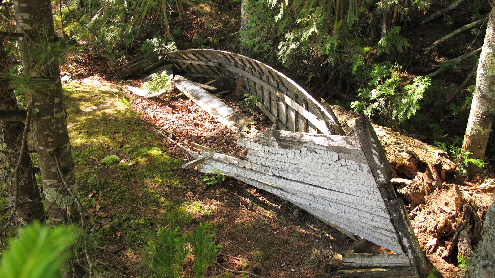 |
| Old boat on Bear Island Apostle Islands National Lake shore |
 |
Bear Island Apostle Islands National Lake shore
|
 |
| Bear Island Apostle Islands National Lake shore |
 |
Bear Island Apostle Islands National Lake shore
|
 |
York Island Apostle Islands National Lake shore
|
After an hour of kayaking we made it to the shoreline of York Island where we had lunch and took a little hike across the island to the other side. It was only around 1000ft to get to the other side which was interesting to see but we want to get going so we got back in the kayak and prepared for another crossing over to our last Island, Sand Island. After another hour on Lake Superior, we got close enough to Sand island where we started to see the sea caves with pencil looking devices weaving in and out of them. A we got even closer and we found civilization. There must have been at least 30 people in kayaks going in different directions through the sea caves and a few small boats driving around Justice Bay.
 |
Sand Island Apostle Islands National Lake shore
|
 |
Sand Island Apostle Islands National Lake shore
|
 |
Sand Island Apostle Islands National Lake shore
|
There was one sea cave that appeared to keep going but upon investigation, the passage ended right after the light zone.
 |
Sand Island Apostle Islands National Lake shore
|
when we got into the cavern, the stratified rock appeared to have different colors of reds and basalt stones embedded into the sandstone depicting ancient lava activity as described from previous research on the region.
I was amazed to see these rock formations and how they seem to be comparable to Utah slot canyon and Arch formations. The waters were still a brisk 45 degrees but the wetsuits that we had on helped out a lot.
After working our way from the sea caves, we headed south to the tip of Sand Island and made our last crossing to the mainland. The winds were with us and after another hour we made it to the mainland shore line. Now we had the task of kayaking to the Cornucopia's before the thunderstorm. Across the lake the clouds started to look dim and the sun began to disappear behind the cloud front which was slowly brewing a thunderstorm. We took a break and headed south down the mainland shore line for a few miles until we started to get to the mainland sea caves.
We passed by a series of tall cliffs containing some sea caves until we got to a bay with the famous balancing rock
We continued down the mainland sea caves section and some of the sea caves started to become more familiar as I have been here in the past and remember going through this section.
The clouds started to creep a bit closer but we were making progress while enjoying our glide down the shore cliffs. Kayaking through some of the water worked arch formations and admiring the dug out caverns appear to be a work in progress as debris from above came rolling down at times. The hanging gardens, moss, tell me that this place is still active especially when the waves are strong and ice is abound.
We continued to work through and under natural bridges as we started to wrap up the end of the trip and make our last push across the bay
As the sea caves started to end the winds picked up and the thunderstorm was starting to gain some momentum. I saw lightening strike across the lake and knew we had to make a push for the last point if we wanted to make it off the water in time.

We paddled and pushed hard to get across the last bay and onto the tip where cornucopia's take out was located. Initially, we were going to be picked up at Little Sand bay on Sunday but we finished our route and even took on more to get to where we are now so we could enjoy some of the other features Michigan had like the lake in the clouds, different waterfalls, and the superior trail. We bend around the last section and our destination is in site. The waves started to develop and we soon found ourselves into the wind with 1s and 2s at 1 to 2 sec troughs. The rain can be seen falling out on the lake from a distance but that distance was shrinking as the storm moved closer to us. The shoreline became more defined and eventually we made it to the harbor and break the shoreline just as it started to rain. In a matter of two in a half days we traveled 56 miles, hiked 5 miles, and visited 11 islands with a tandem kayak. That was a great workout and a nice adventure on the great lakes. We were amazed to see how pleasant the conditions were for us and how we just barely missed the clouds and the thunderstorms. The following day they had 2-4 ft waves and thunderstorms in the area so we were lucky to finish when we did.

APOSTLE ISLANDS MORE PICS: https://www.flickr.com/photos/exploration-worldwide/sets/72157645156849528/
WISCONSIN WATERFALLS: https://www.flickr.com/photos/exploration-worldwide/sets/72157633351859726/
SHIPWRECKS OF THE APOSTLE ISLANDS: https://www.flickr.com/photos/exploration-worldwide/sets/72157633273034234/
 |
Sand Island Apostle Islands National Lake shore
|
 |
Sand Island Apostle Islands National Lake shore
|
 |
Sand Island Apostle Islands National Lake shore
|
 |
mainland Sea Caves Apostle Islands National Lake shore
|
 |
Mainland Sea Caves Apostle Islands National Lake shore
|
 |
Mainland Sea Caves Apostle Islands National Lake shore
|


One thing this trip made me thankful for is that thankfully bugs are not the same size as us, if they were, we would be totally screwed!!!!...like a vampire apocalypse. If I ever get a chance to return to the Apostle Islands I will want to get out to Stockton island to visit the shipwreck, the balanced rock and sea caves of the area. There is a ferry that takes campers out to this island which also can be a good place to start a kayak trip to outer island and the remaining north eastern islands of the apostle islands. There are also 3 shipwrecks in deep water that I will like ot visit if I made my way back out there. One of the wrecks is at a depth of 185 ft called the T.H. Camp which is a wooden tugboat in pristine condition. Read more about it here. http://www.superiortrips.com/ApostleIs/THCamp_Shipwreck.htm
WISCONSIN WATERFALLS: https://www.flickr.com/photos/exploration-worldwide/sets/72157633351859726/
SHIPWRECKS OF THE APOSTLE ISLANDS: https://www.flickr.com/photos/exploration-worldwide/sets/72157633273034234/
0 comments